Trekking in Val Nervia, from Buggio


Edited by:
Maria Grazia Schiapparelli
Updated at: 10/05/2026
Access
Exit the Autostrada dei Fiori at Ventimiglia and take the Via Aurelia to Nervia, drive up the Nervia valley via Camporosso and Dolceacqua; the latter is worth a stop, the bridge and castle ruins are interesting; continue on to Isolabona and Pigna, known for its thermal baths, a possible interesting after-trip. From Pigna, follow the direction of Colla Langan and turn left for Buggio. Take note of the timetable for the Pigna-Buggio bus, you will need it to pick up your car on the third day (Riviera Trasporti bus company).
Introduction
Interesting circular tour in a very beautiful and special area, both for the morphology of the terrain and the war fortifications, and also for the particular spring blooms.
Description
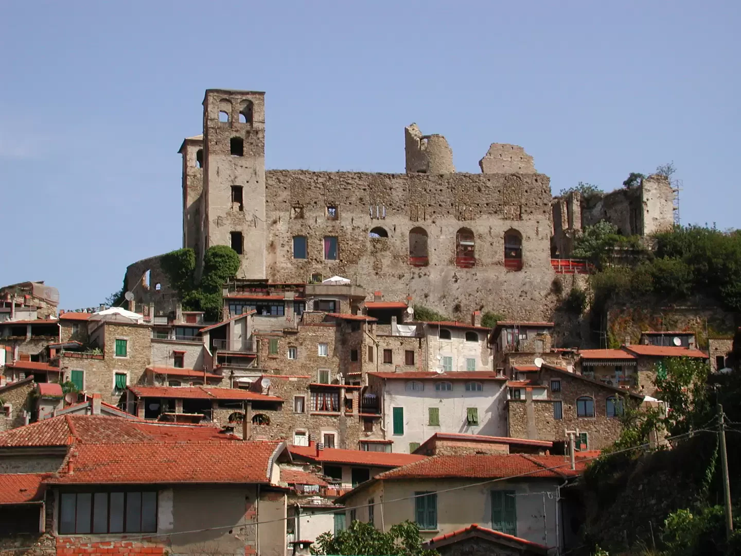
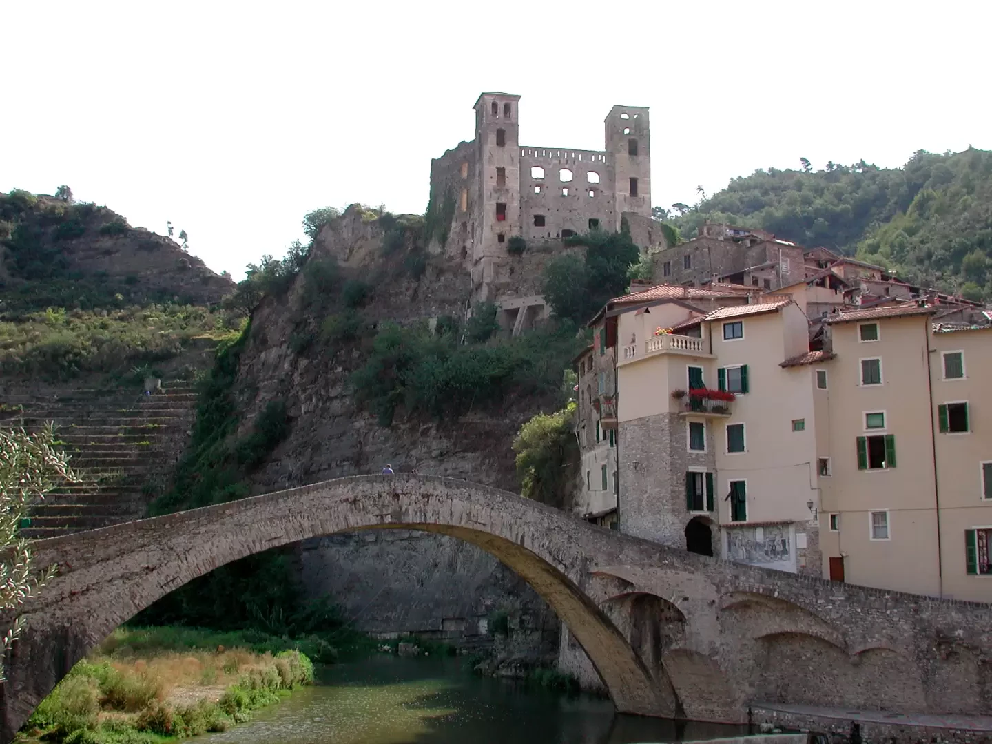
Interesting circular tour in a very beautiful and special area, both for the morphology of the land and for the war fortifications, and also for the particular spring blooms. First stop: Below Toraggio there is a herd of wild horses, beautiful; we did the tour in August, there were very few people, more bikers than hikers; the paths were perfumed with lavender, the appearance of wild horses in the fog made us experience emotions of another era. Beware: throughout the whole tour we did not find a single water source, even those that should have been there were dry!!! Take adequate supplies before setting out. Dolceacqua: the name may derive from the presence here of the rustic estate of a Roman named Dulcius, or from an ancient toponym of the Celts, Dussaga. This area was already inhabited five centuries before Christ, a period to which some Iron Age castellieri (fortifications) erected for defensive purposes on the surrounding heights date back. The first documents that speak of the town date back to 1151, the time when the castle was built, purchased in 1270 by the Genoese captain Oberto Doria, the one who defeated the Pisans at the Battle of Meloria. Buggio has ancient and beautiful stone houses; it is currently a hamlet of Pigna, while in the past it was a municipality in its own right. Legend has it that it was founded by three thieves who escaped from France via the Incisa Pass, in the 4th century AD; according to a story handed down from father to son, in the 8th century AD, Saint Siagrio, bishop of Nice and grandson of Charlemagne, went to Buggio to confirm children; it is unusual that the only existing church dedicated to the saint is located around here. Buggio belonged to Genoa for a time, then passed to Piedmont; it was the birthplace of Finance Minister Siccardi. A hundred years ago it had about a thousand inhabitants, now it has about a hundred. In addition to hiking and mountain bike trails, the border area above the Allavena refuge also has historical significance; the Cima di Marta and the Balconies of Marta, which overlook the Roja valley as far as the Saccarello, were fortified by the Austro-Piedmontese and became the scene of bloody battles against the French in 1794. Towards the end of the 19th century, shelters and barracks were built in the same area, served by military roads that still exist today. The most important connection started from the Col di Tenda, with a military road that reached a hill where there were 100 men, from which a dirt road went up to Saccarello, where a cannon battery was mounted. Cima Marta, due to its strategic position, was the most important post of the entire watershed, because through the mountain paths of the area the forts of the Colle di Tenda and the barricades of the Ligurian Alps could be bypassed in one move. For this reason, the position was further strengthened with five batteries capable of hitting French targets, and barracks for 500 people and 30 animals were built in the area. The entire area between Toraggio and the Marta balconies had a first line and a rear line of defence. Between 1931 and 1939, an underground complex was built inside the mountain, under the Marta balconies, which is the largest in the Alpine Wall of the Western Alps and one of the largest fortifications of the last century. The complex has 1,500 metres of tunnels over a height difference of 140 metres, connected by very steep stairs; it consisted of a series of emplacements all autonomous (in terms of water, provisions, ventilation, ammunition, armaments) and connected by tunnels, with cannons aimed at French targets; all this complex fired only a few shots, until in 1943 the works were abandoned and the border rectified, so that they found themselves under France and were plundered by locals and partisans. The complex can still be visited with appropriate caution, but NEVER go there alone and carry torches.
Second stage: Buggio - Rifugio Allavena
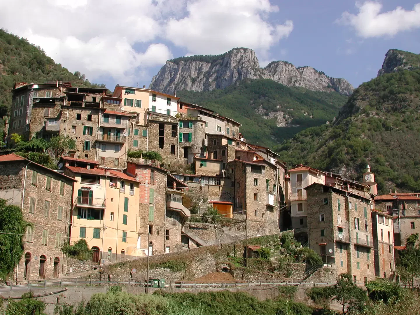
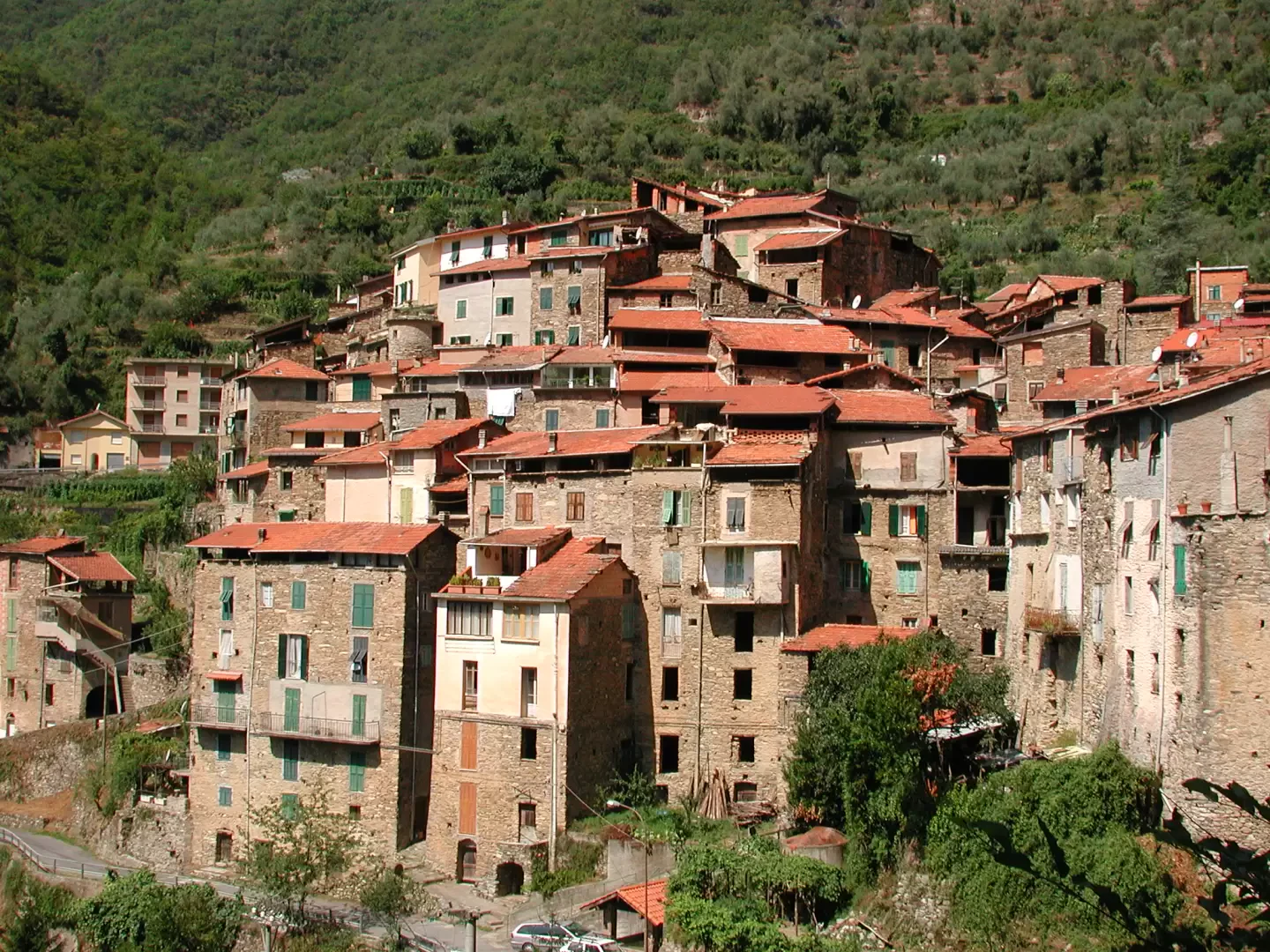
Park your car in the small square in Buggio (445 m), and take a look at the orientation board; there are two paths going up to Colla Melosa: one, that of the Tane, which starts high above the hamlet, is classified EE; we preferred the easier one, the junction Path N° 10, marked with red and white stripes, which starts from the car park, first skirts and then crosses the stream; it is a beautiful mule track that climbs between the terraces, at times shady, while the panorama widens over the Nervia valley cultivations and Buggio, at the foot of Monte Toraggio. The first stop is the group of houses around the Madonna di Lausegno (722 m); here the path climbs steeply, amid fragrant cultivated fields, then crosses the slopes with a long shift, resuming a determined ascent near a group of ruined huts, in dense woodland. The forest changes as one ascends: first olive groves, then hazel, then beech, holm oak, and finally pine and larch. After the stretch among the conifers, the path comes out onto a road, which must be followed to the left, at the Tenarda dam (1330 m); this is the stretch that we liked least: continuing along the road, one descends quite a bit, losing height until below the dam, one crosses it, and climbs back up on the other side of the valley, skirting the barbed wire that runs alongside the reservoir for quite a while; this part seemed decidedly ugly to us, and much longer than the last signpost: taking into account the loss of altitude, it is about 300 metres of elevation gain, we already have almost 1000 in our legs, with a not exactly light rucksack, and the displacement is considerable; the Allavena refuge (1540 m), can only be seen a few metres away. In front of us is Monte Pietravecchia, and to the side, to the left, Monte Toraggio: first surprise: it seems to be in the Dolomites... So far, from Buggio, we haven't met a single person!!! (1140 metres dsl + the ascent to Tenarda, 8 km, 4h00'). The Allavena refuge (70 bunk beds, Cai di Bordighera, open from 1 December to 2 November) can also be reached by car from Pigna or Triora, via the tarmac road that passes through Colla Langan. Beyond the Allavena refuge is the Grai refuge, at 1900 metres altitude, but it is not guarded, at least it wasn't when we did the tour. The Allavena refuge is a nice building with neat little rooms, the possibility of a hot shower and a good meal; the mobile phone doesn't work here, you have to move a hundred metres south. In August there were quite a few bikers, riding the challenging descent to Ventimiglia, which is part of the Limone-Ventimiglia and Geneva-Ventimiglia routes. The start of the mule track Trekking in ValNervia - © 2008 Maria%20Grazia%20Schiapparelli Trekking in ValNervia - © 2008 Maria%20Grazia%20Schiapparelli Trekking in ValNervia - © 2008 Maria%20Grazia%20Schiapparelli Trekking in ValNervia - © 2008 Maria%20Grazia%20Schiapparelli Madonna di Lausengo Interior of the chapel Climbing among the cultivated fields The Ruscello wood Trekking in ValNervia - © 2008 Maria%20Grazia%20Schiapparelli Trekking in ValNervia - © 2008 Maria%20Grazia%20Schiapparelli Trekking in ValNervia - © 2008 Maria%20Grazia%20Schiapparelli Trekking in ValNervia - © 2008 Maria%20Grazia%20Schiapparelli Conifers Optimistic sign! At last, the Allavena Refuge Evening mists Rifugio Allavena - Rifugio Muratone From the Allavena refuge there are several possible itineraries, on foot or by mountain bike; we have chosen to climb up to Pietravecchia, descend to the Incisa pass, walk along the stretch of the Strada degli Alpini road under Monte Toraggio, and then climb up to the Muratone refuge, where we will spend the night. Along the way, no water: I confess that we were at our limit, because it was also quite hot, and the Muratone refuge was practically open just for us, around 5.30 p.m., so when we arrived around 4 p.m. it was closed, there wasn't a drop of water around, and we had been out there since 8 a.m. From Rifugio Allavena (1540 m) take the dirt road uphill to a fork in the road, to the left, with clear signs of the Sentiero degli Alpini, a path carved into the rock of the almost perpendicular walls of Mounts Pietravecchia and Toraggio, built by the Alpine troops to carry supplies and weapons on muleback to the fortifications in the area, and in particular to Cima Marta, in secret from the French, who were entrenched on the other side. The trail remained abandoned for almost 50 years, and was only recently restored and made safe by the CAI of Bordighera (some sections had in the meantime collapsed); chains were placed at the most exposed points. The path, although spectacular and impressive, is not difficult, it is rated a first grade on the difficulty scale, but is absolutely not recommended for those suffering from vertigo. At the crossroads, take a left, immediately encountering some chains; after a while we left the path of the Alpini to follow the sign that leads to the Pietravecchia, with a beautiful path through a larch wood, because we decided to see the panorama from above, before descending to the next refuge. Following the dirt road again at some point, we arrived at the Valletta pass (1909 m), which is not very scenic, and we decided to make a diversion to the Valletta tip. From the latter, with a 360-degree view, where a swarm of locusts nibbled away at my shirt drying on the grass without me noticing, we descended to the pass of the same name and climbed back up to Pietravecchia (2038 m, 1h40'), along what used to be an old military road, to the left of the pass. The view from the point is spectacular, especially of Monte Toraggio in front of us, shame about the fog that was coming in from the sea....Redescended back to the Valletta pass, we continued on the west side of Pietravecchia, on a nice downhill path, following the Ventimiglia sign on the bikers' plaque. The route is very beautiful, easy on foot, a little less so for mountain bikers, because they have to take it by the hand or on their shoulders for long stretches. We descend behind Monte Pietravecchia with traverses and then with steep turns, between lavender bushes, and views of the French Alps, arriving at the col where the ridge that climbs to Monte Toraggio begins: we are at the Incisa Gorge (1685 m). When we walked along the path, in August 2005, there were no signs; there are two paths, one that continues north, frequented by bikers, classified E, easy, as a continuation of the one travelled so far, behind Monte Toraggio, the other that descends in tight turns to the south, supported by dry stone walls, and joins the path of the Alpini, classified EE, expert hikers; we chose this path, and found ourselves on the spectacular ledge carved out of the rock and equipped with chains; it continues in safety, crossing and re-climbing various channels, until we reach the meadows south of Toraggio. At a certain point there is a diversion: to the right, red arrow, for the summit of the mountain, straight on, yellow bolli, for the Muratone refuge. We gave up on the point because it was now immersed in fog, continuing on our path, which from now on presents no more problems, except for the interminable length, because it descends very gently going in and out of many valleys, and from a certain point onwards it once again picks up the bikers and hikers who have passed behind the Toraggio, giving them precise instructions at the most dangerous points (for those who take it by bike, on foot there is no problem); henceforth ignore the various detours, which are very well signposted, and continue straight on. From a certain point onwards, there was a lot of horse dung on the path, so we thought it was a bridle path, but instead it was the 'sign' of the presence of a fine herd of about forty or so animals in the wild, elegant state. All around us fragrant flowers, thyme and lavender bushes, thistles. We arrive at the Corvo gorge (1403 m), behind which is France, and descend further, partly by path and then by dirt track, to the Muratone refuge (1180 m, about 7 hours from the Allavena refuge). The refuge is the refurbishment of a Guardia di Finanza barracks, and we are told that it is currently unguarded (in case it is difficult to find the keys, there is another stopover a couple of km further down the valley at the Gola di Gauta); the tables under the trees overlook the Nervia valley and the view reaches as far as the sea; inside, the walls are covered with splendid photographs of the herd of horses, taken even in the snow, and spectacular photos of flowers; this area is a botanist's paradise: daffodils, peonies, fritillary, various species of gentian, mountain tulip, red lily, martagon lily, St John's lily, Allioni evergreen, various species of orchids, the spinalba. Some species are very rare.
.Photo gallery Trekking in ValNervia - © 2008 Maria%20Grazia%20Schiapparelli Trekking in ValNervia - © 2008 Maria%20Grazia%20Schiapparelli Trekking in ValNervia - © 2008 Maria%20Grazia%20Schiapparelli Trekking in ValNervia - © 2008 Maria%20Grazia%20Schiapparelli Trekking in ValNervia - © 2008 Maria%20Grazia%20Schiapparelli Allavena Refuge and Monte Toraggio Going up to Colle Valletta Colours Thistles The beautiful path among the larches Trekking in ValNervia - © 2008 Maria%20Grazia%20Schiapparelli © 2008 Maria%20Grazia%20Schiapparelli Trekking in ValNervia - © 2008 Maria%20Grazia%20Schiapparelli Trekking in ValNervia - © 2008 Maria%20Grazia%20Schiapparelli Trekking in ValNervia - © 2008 Maria%20Grazia%20Schiapparelli Trekking in ValNervia - © 2008 Maria%20Grazia%20Schiapparelli Ascending the lake of Tenarda Vers la France From the Punta della Valletta Toraggio and Sentiero degli Alpini Toraggio from Pietravecchia Trekking in ValNervia - © 2008 Maria%20Grazia%20Schiapparelli Trekking in ValNervia - © 2008 Maria%20Grazia%20Schiapparelli Trekking in ValNervia - © 2008 Maria%20Grazia%20Schiapparelli Trekking in ValNervia - © 2008 Maria%20Grazia%20Schiapparelli Trekking in ValNervia - © 2008 Maria%20Grazia%20Schiapparelli Descending from Pietravecchia Lavender Towards the Colle dell'Incisa Alpine Path South of the Colle dell'Incisa Colle Muratone - Pigna On the evening of the second day, the sky towards the sea darkened and flashes of lightning and thunder began to rumble. The next morning it wasn't raining, but it didn't look so good either... We decided to descend immediately to Pigna. In 2005 there was a path leading down from the Muratone pass directly to Pigna; if we stayed overnight at the Gauta gorge, which can be reached from below by asphalted road, a small diversions connects to the same path. The path is number Trail No. 8, is six kilometres long and has a descent of 975 metres; consider at least a couple of hours, because it has a lot of shifting and also some climbing. The path descends very steeply at first, through uncultivated meadows and thickets (we heard animals in the undergrowth, but did not see them), then ascends slightly and crosses northwards until it reaches a dirt track to follow uphill; We then descend towards a small church and then along a lovely pedestrian path along the stations of a Way of the Cross to Pigna, where we return to the car by bus; we missed the bus by a handful of minutes, and walked another 7 km, from the 183 metres of Pigna to the 445 of Buggio, passing above the inviting Pigna spa... We were told that in the forest there are deer, wolves, and the ever-present wild boar; high above we saw two eagles flying. Photo Gallery Trekking in ValNervia - © 2008 Maria%20Grazia%20Schiapparelli Trekking in ValNervia - © 2008 Maria%20Grazia%20Schiapparelli Trekking in ValNervia - © 2008 Maria%20Grazia%20Schiapparelli Trekking in ValNervia - © 2008 Maria%20Grazia%20Schiapparelli Trekking in ValNervia - © 2008 Maria%20Grazia%20Schiapparelli Sentiero degli Alpini A beautiful stretch Map Towards the Muratone Refuge Aerial passage for MTB Trekking in ValNervia - © 2008 Maria%20Grazia%20Schiapparelli Trekking in ValNervia - © 2008 Maria%20Grazia%20Schiapparelli Trekking in ValNervia - © 2008 Maria%20Grazia%20Schiapparelli Trekking in ValNervia - © 2008 Maria%20Grazia%20Schiapparelli Trekking in ValNervia - © 2008 Maria%20Grazia%20Schiapparelli Garofanini More flowers Towards the Corvo Pass Refuge Muratone Thickening of clouds Trekking in ValNervia - © 2008 Maria%20Grazia%20Schiapparelli Trekking in ValNervia - © 2008 Maria%20Grazia%20Schiapparelli Trekking in ValNervia - © 2008 Maria%20Grazia%20Schiapparelli Trekking in ValNervia - © 2008 Maria%20Grazia%20Schiapparelli Trekking in ValNervia - © 2008 Maria%20Grazia%20Schiapparelli Descent to Pigna Terraces Pigna Toraggio and Pietravecchia from Triora
External links
ww.altaviadeimontiliguri.it
Total time: 14h00' First day: 4h00' Ascent time: 7h00' Descent time: 3h00' Height difference: Ascent1095+120 m (1st day) Ascent498 m Descent 850 m (2nd day) Ascent262 m (3rd day)
Photo gallery
Comments (0)
Sign in to leave a comment