Trident du Tacul

Edited by:
Giancarlo Beretta
Updated at: 06/10/2024
Introduction
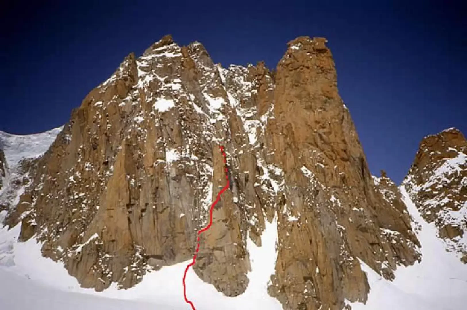
It is an elegant, slender granite tower that culminates in three peaks and is located at the end of the eastern buttress of the Clocher. The route climbs diagonally from west to south and finally reaches the summit from the east, circling it like a spiral. The climbing is really beautiful and satisfying, especially in the upper half, and on excellent rock for a total of eight lengths with difficulties ranging from III to IV+ and a V+ passage halfway up. From the summit, there is a grandiose, close-up view of the looming Grand Capucin, on the south face of which you can see the ever-increasing number of climbers engaged on the difficult routes traced out on it.
Description
We leave the hut and with an easy glacier path, very well marked, we first cross Col des Flambeaux (3407m), overlooked by the aerial pylon of the gondola, and then turn left and descend north-westwards to a glacier plateau. From here, up and down, cross an area with large crevasses and turn left in the direction of the Combe Maudit and from the beginning of this towards the imposing southern slope of Mont Blanc du Tacul with its "satellites" crowning it: Pyramide, Clocher, Chandelle, Trident, Grand and Petit Capucin, pic Adolphe Rey and finally Pointe Lachenal. One then reaches the base of the snowy cone between the Chandelle and the Trident, the Couloir du Trident, and ascends it, passing the terminal at its best point, for about ten metres and the start of the route is located to the right on the rocks of the west face. The route is climbed for three lengths (III, III+, one IV passage respectively) passing first a series of short vertical jumps interrupted by terraces and, sloping to the right (south), climbing small chimneys and beautiful cracks. When you reach the third belay, you find a wide terrace just below the south edge. Climb an oblique crack to the right to reach the bottom of a chimney-corner. Climb up a small corner through a rounded horizontal crack (V) and then climb over the crack, overhanging at the start, which is beyond the chimney-diedrope coming out to the right on the south-east face: this is the most difficult point of the route (IV and A0 with 3 pitons in place; V+ if free-climbed). Climb right again with two lengths (III, III+ respectively) exposed and oblique and you reach the terraces situated at the foot of the terminal wall on the east face about 80 m high.
From the central terrace, climb laboriously up a chimney (IV+) and then, via a series of wide cracks that lead towards the notch between the central and south summit (right), you reach a terrace. We continue upwards for about ten metres and cross to the right for a few metres (IV+, IV with a piton on site) to take a crack that leads us to the summit of the central peak (IV+ with a piton on site). From this you can reach, from the notch between the two, the south summit with a very exposed and delicate traverse on its east side (IV+).
The descent is equipped for abseiling along the entire route.
Because of the beauty, difficulty and excellent granite of the numerous routes on this "satellite", it is easy to find crowds both during the ascent and during the abseil descent.
- AA.VV., Monte Bianco (1), Guida Vallot, Edizioni Mediterranee, Roma, 1988
- Gino Buscaini, Monte Bianco, Vol.1, Guida dei Monti d'Italia, CAI e TCI, Milano, 1994