Longhede Peak, from Champlong

Edited by:
Massimo Martini
Updated at: 25/10/2025
Access
From the motorway exit at Châtillon/Saint-Vincent, turn left and follow the main road up to a roundabout, take the second exit and head west on Via E. Chanoux through the centre of Châtillon, cross the Marmore stream and turn right first onto Via Menabrea and then Via Martiri di Chesod before turning onto the . Follow the regional road as far as Antey-Saint-André and then take the
to follow as far as Col Saint-Pantaléon. From the pass, descend for a few kilometres to the hamlet of Cheresoulaz where, turning right, take the until the crossroads for Champlong: turn right and follow the road up to the picnic area where, a little further on, you will find a small car park where you can leave your car.
Introduction
From the start, you can immediately appreciate the wide grassy ridge that links the peaks of Cima Longhede and Becca d'Aver. Below is a description of the direct access route to Cima Longhede, the summit on the left.
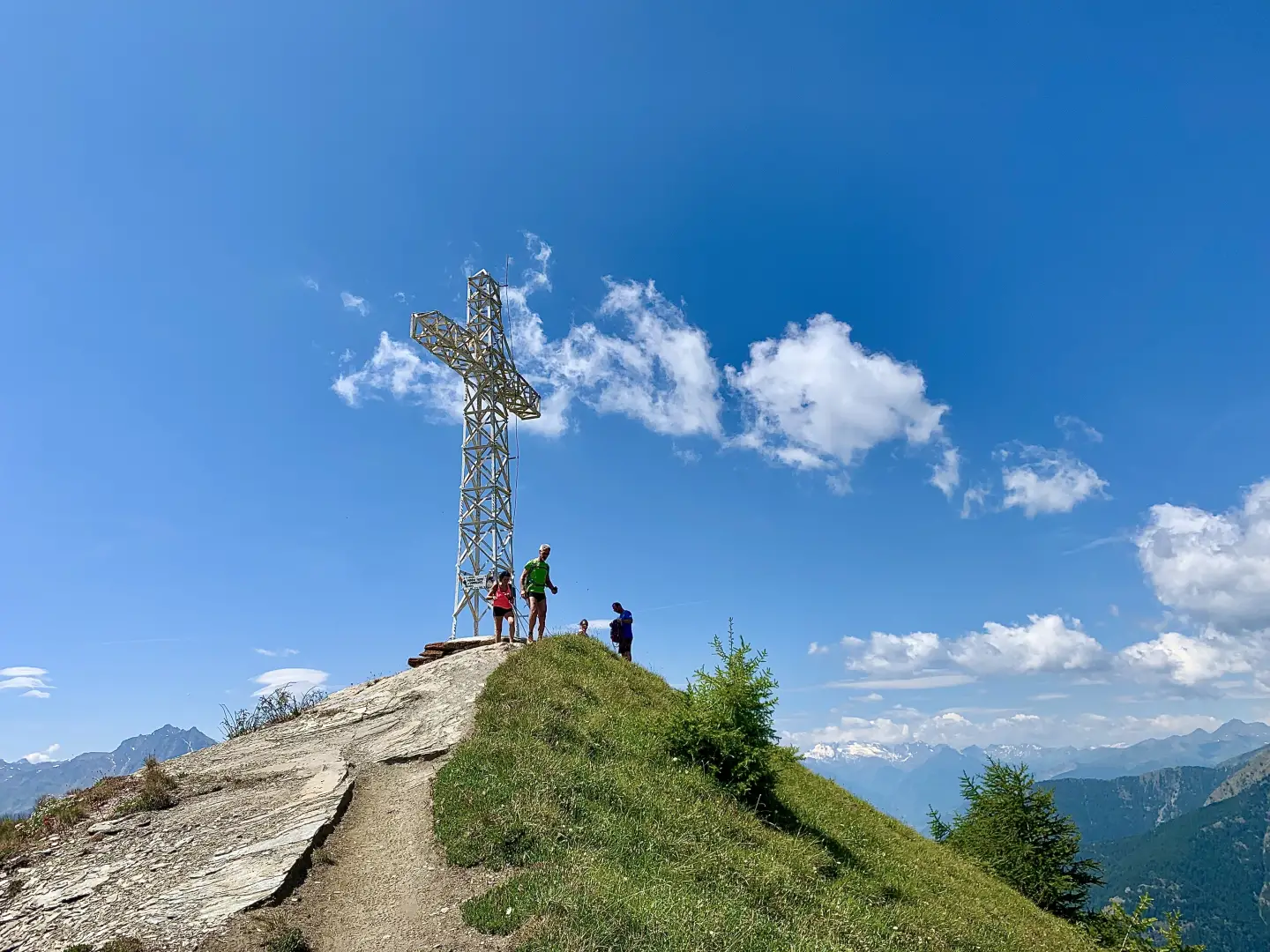
The ascent route does not present any particular difficulties and once at the top it offers pleasant panoramic views over the middle Valle d'Aosta. The summit is surmounted by a monumental white metal cross, 10m high, erected in 1970 on the initiative of the Verrays parish priest Gino Perron together with the Penne Nere group and the Marble Workers.
.Description
0h00' From the car park, head in the direction of an isolated hut and take the little dirt road that immediately turns right towards the Champlong mountain pasture. After a few minutes, overlook the small road on the right that leads to the Champlong alpine pasture (1656m, cheese for sale on site) and continue on the main route, turning right shortly afterwards. Shortly afterwards, disregard a small road on the left with indications of the various Nordic walking trails in the area and continue slightly uphill in an easterly direction through a stretch of larch forest. During this part of the route, there are small glimpses of the Champolong picnic area below, with its small lake known for the presence of giant leeches, until you reach the spacious clearing of Col des Bornes (1781m), where you will come across a signpost indicating the ascent to Becca d'Aver.
0h25' Turn left and take path
that enters the cool coniferous forest. Go through a short semi-flat section and then begin to gain height with greater intensity along the wide and evident path, marked by yellow arrows on the stones and by the marks that identify its number. Around an altitude of 1900m, the forest begins to thin out and from the trees there are interesting glimpses of the mountains opposite in the central valley: from Barbeston to Mont Emilius. Pass a barren stretch with some small stones before turning slightly to the left to reach a short plateau where there are two benches and a table: an excellent spot to take a short break. Continue for a few dozen metres before meeting the signpost indicating the junction with path
coming from the main town of Verrayes.
1h00' Continue along path
as the sparse forest gives way to alpine meadowland, climbing the steep slope thanks to a series of twists and turns that allow you to gain height quickly. After the most demanding section, the trail reduces its gradient and runs along a diagonal that cuts across the slope in an upward slope until it first reaches some ruins on the ground level and, shortly afterwards, the junction with trail
coming from Champtorné: from this point, a pleasant view of the Matterhorn and the Monte Rosa massif can be appreciated.
1h30' Neglect the downhill path to the right and turn left to walk the short uphill stretch that leads to the Aver farmhouse (2345m).
1h35' Leave trail
and take a small single-track path to the left, which practically on the level, after skirting a ruin continue between the avalanche barriers and then on the bare slope until reaching the summit ridge and the junction with trail
coming from Praz (Saint-Barthélemy valley).
1h50' By now the summit is visible, continue straight on with a few ups and downs until you reach the short final ramp leading to the summit of Cima Longhede (2416m, 2h00' where the large metal cross is located, making it visible from the start. The panorama is noteworthy: in addition to privileged views of the central valley and its most iconic peaks (Mont Emilius, Becca di Nona and Tersiva), the view of the Vallon de Saint-Barthélemy with the entire mountain crown enclosing it like a little jewel box is very interesting.
The descent follows the same route as the ascent 1h15'.
General information
Signposts: s.n,
, s.n,
Type of route: a/r
Recommended period of time: May, June, July, August, September, October
Sun exposure: south
Mappe
We have been there

Edited by:
Ivo Giansetto
Becca d'Aver e Cima Longhede
Giornata molto calda e poco ventilata. Salito con una coppia, padre e figlia, che hanno scelto di scendere a Chantornè.

Edited by:
Rita Tarussello