Refuge Mont Fallère, from the Vétan dessus car park


Edited by:
Maurizio Loconti
Updated at: 23/10/2025
Access
Lasciare l'autostrada e, dopo 450 metri, uscire dallo svincolo immettendosi a destra sulla strada regionale per la valle di Cogne. Dopo 400 metri, alla rotonda, prendere la seconda uscita per entrare nella strada statale , da seguire per circa 3 chilometri attraversando l'abitato di Saint-Pierre fino al villaggio di Luboz. Svoltare a destra su Via Corrado Gex, da percorrere per 300 metri, quindi svoltare nuovamente a destra sulla strada regionale , da seguire per circa 7,7 chilometri fino a Saint-Nicolas. Poco oltre il centro principale, a un bivio, proseguire diritto sulla strada regionale seguendo le indicazioni per Vétan.
Giunti a Petit Sarriod, lasciare la strada regionale e svoltare a sinistra. Proseguire lungo la strada comunale attraversando i villaggi di Person, Grand-Sarriod e Gerbore fino a raggiungere, dopo 4,2 chilometri, Vétan, dove si trova un ampio parcheggio al termine della strada.
[0h29'] - [18,2km]
Come arrivarci con GMaps
Come arrivarci con Apple Maps
Le indicazioni fornite sono state verificate con attenzione alla data di rilevamento dell'itinerario. Tuttavia, si consiglia vivamente di controllare eventuali variazioni intervenute successivamente, soprattutto riguardo al percorso di accesso al punto di partenza. Prima di intraprendere il viaggio, è opportuno consultare strumenti di navigazione aggiornati per ottenere indicazioni stradali precise e attuali. Raccomandiamo l'utilizzo di app per la navigazione satellitare, come Google Maps o Apple Maps, per garantire la massima accuratezza e sicurezza del tragitto.
Description
We set off, following the symbols and passing a little wood, and then take a right, descending to ford a stream. Walk along two more streams (there is a lot of water that makes a pleasant... deafening... noise...) and, below the Alpe di Tholes, keep to the right (20'). You thus enter the flat valley of the Méod stream. At a crossroads (20'), turn left, leaving the track to the right for Alpe Mont Loe. We now climb, somewhat laboriously for 30', through a beautiful larch forest. Behind, the snow-capped peak of the Grivola, 3969 m, towers up, as you continue up the ridge, until you find a track where you turn right (20').
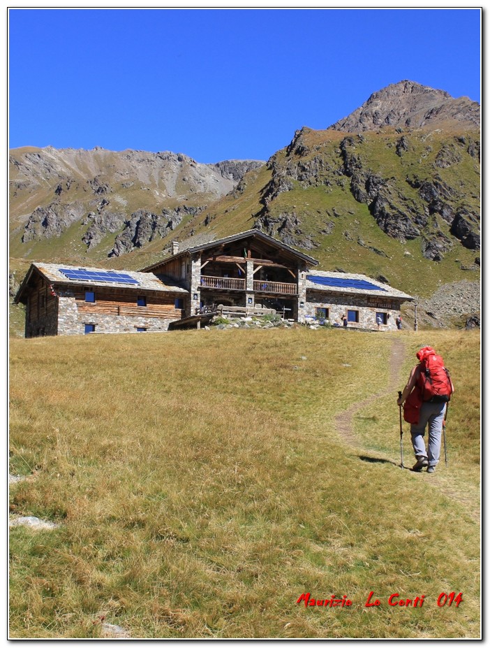
A nice dirt track accompanies you up to the hut, and opposite you can see Mount Fallere 3090 m. Along the way, there are several examples of sculptures by the artist Siro Vierin and others. The works make the path varied, a kind of open-air museum, and it is an incentive for the little ones who will be curious to discover... the next ones. Some are really nice... like the one that could be called: 'When he runs away... he runs away...'. Finally, it is from the refuge... at 2,385 m - 45' for a total of 2h15 for the outward journey.
Other sculptures, also being worked on, are at the hut, which is run by the very author of these works... The view from the hut is stupendous and one can create unique photos, with all the peaks silhouetted in front... (link http://cralgalliera.altervista.org/Rmf07VistaDaRifMontFallere.pdf ).
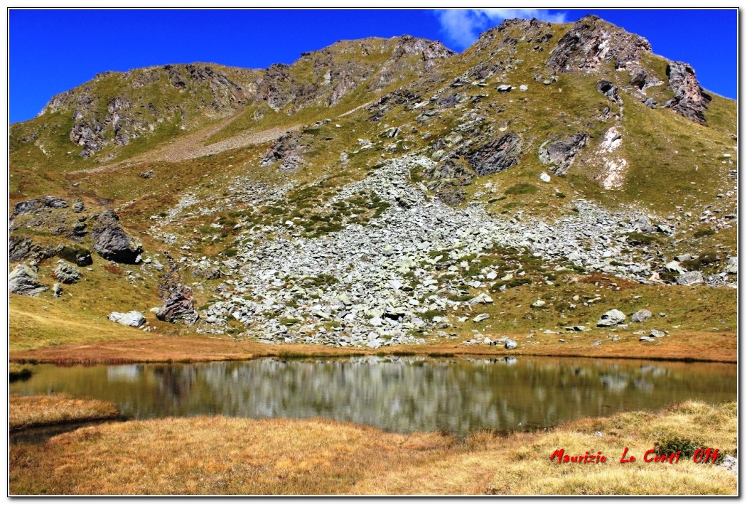
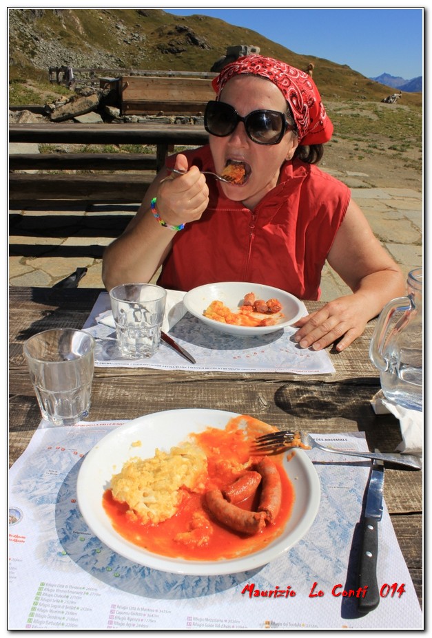
The cuisine is well prepared, with reasonable prices, and the service is excellent (courteous and fast). After lunch (Yum!), we look up the valley... then, in 10', we arrive at Lake delle Rane (2367 m). The lake is a crossroads of paths... and you choose the downhill one...
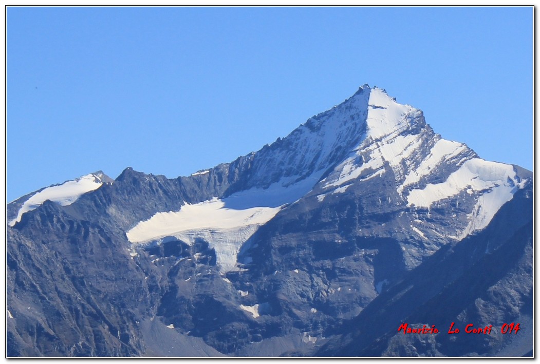
Differently uphill, you proceed towards the two lakes of Mort and Fallere (the paths split up later on...). The yellow arrows are present... but very sparingly... You pass Alpe Tsa della Comba (source - 30' - 2260 m) and turn abruptly to the right (still a few symbols). Further on, there is a nice view of Vetan. You continue to lose metres and when the trees begin to be more numerous, there is a symbol on a boulder (30') and you go, suddenly, right... (no reference or arrow!). Continue downhill... until you reach Alpe Mont Loe (1985 m). Another fork (20'), which is difficult because it is not signposted: leave the dirt track and cross the stream at the water collection point and continue on level ground... with a beautiful view of the Alpe Mont Loe area... until you reach the morning fork (10'), where the loop ends! In 30' you are at the finish... a total of 2h/2h15 for the return trip (given the difficulty of finding the route, proceed slowly - for the less experienced, it is advisable to retrace your steps...). All in all: diff. E (the return is almost EE, a couple of forks are NOT marked!), difference in altitude 600 m tot. A and R 4h30 - splendid weather! On the return journey by car, we also took a photo of the superb Grand Combin massif (4314m) and, before heading back, we refuelled at the Carrefour hyper petrol station, near the entrance to Aosta East, at 1.705 E!!! Here are some previews... 1
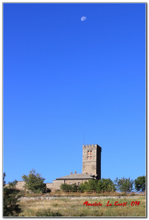
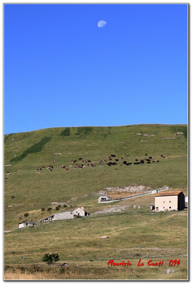
Particular Moon Over Saint Pierre: http://cralgalliera.altervista.org/Rmf01LunaSuSaintPierre.jpg 2 Moon Runs On Rutor Glacier: http://cralgalliera.altervista.org/Rmf02LunaCorreSuGhiacciaioRutor.jpg 3 Moon Runs On Alpe Chatalanez: http://cralgalliera.altervista.org/Rmf03LunaSuAlpeChatalanez.jpg 4 Arriving at Rif Mont Fallere: http://cralgalliera.altervista.org/Rmf04ArrivandoAlRifMontFallere.jpg 5 Frog Lake: http://cralgalliera.altervista.org/Rmf05LagoRane.jpg 6 Grivola detail http://cralgalliera.altervista.org/Rmf06Grivola.jpg 7 Overview Mountain view on a beautiful day From Rif Mont Fallere... Fantastic composition photo!!!!!!! http://cralgalliera.altervista.org/Rmf07VistaDaRifMontFallere.pdf 8 Polenta at the refuge: http://cralgalliera.altervista.org/Rmf08PolentaRifMFallere.jpg In addition, pdf files are available at the links: Part ONE http://cralgalliera.altervista.org/RifugioMontFallere014A.pdf Part TWO http://cralgalliera.altervista.org/RifugioMontFallere014B.pdf More info: http://www.cralgalliera.altervista.org/esc.htm http://www.cralgalliera.altervista.org/gite014.jpg The new newsletter an Idea for the Weekend: http://www.cralgalliera.altervista.org/nuova_pagina_24f.htm Photo : http://www.cralgalliera.altervista.org/anno2014.htm http://www.cralgalliera.altervista.org/altre2014.htm Enjoy! hello everyone NB: in the event of an excursion, always check with FIE, Cai, any park authorities or other institutions, pro loco, etc., that there have been no changes that have increased the difficulties! No liability is accepted. This text is purely indicative and not exhaustive.
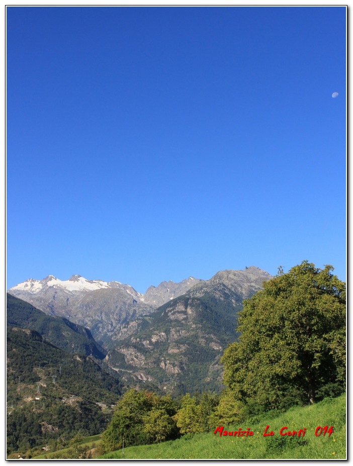
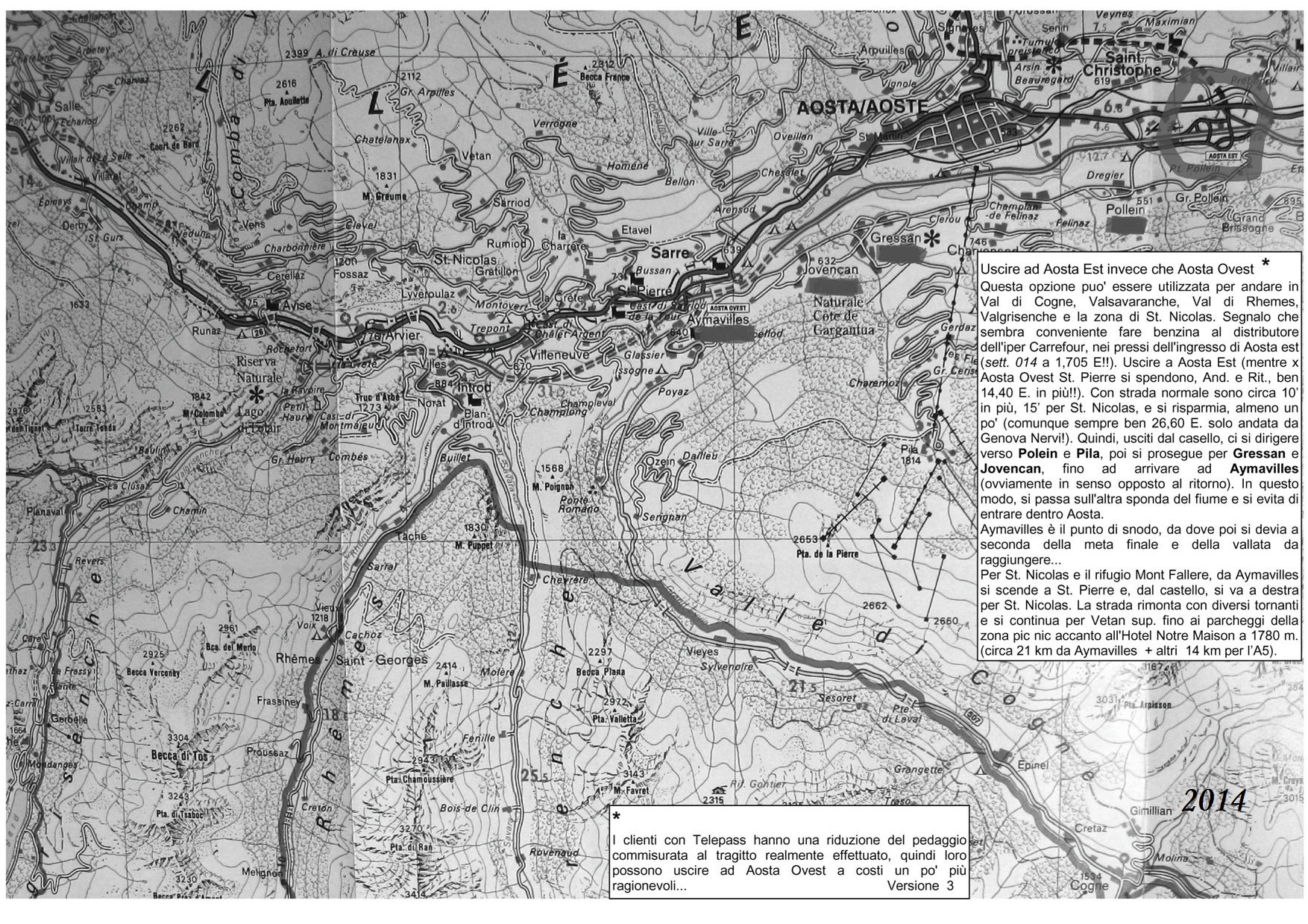
refuge Mont Fallere Panoramas Doc from the refuge Mont Fallere and the lake of the Frogs (St. Nicolas - Ao) locontim via: Access from Vetan sup. Author: Maurizio Lo Conti Signposts: Paline and yellow numbering, typical of the Aosta Valley Date of survey: 13/09/2014 Cover photo: Arriving at the Mont Fallere hut © 2014 Maurizio Lo Conti Type of route: Partly circular Difficulty: E Recommended Period: June, July, August, September Overall Time: 4h30 Departure Height: 1780 m Arrival Height: 2385 m Drop: 600 m Maximum Height: 2385 m Finally a super Day! Such as to justify the long, but not very tiring (almost empty motorway) trip to the Valleè. We leave Aosta Est in 2h15 (while for Aosta Ovest St. Pierre you have to spend a good 14.40 E. more!!). By normal road, it's an extra 15 minutes (info http://cralgalliera.altervista.org/MappabnAosta.jpg ) and you save, at least a little (still a good 26.60 E. from Genova Nervi!). You head towards Polein, Pila, Gressan, Jovencan and Aymavilles (obviously in the opposite direction on the way back), then from Aymavilles you descend to St. Pierre and, from the castle, you go right to St. Nicolas. The road climbs up with several hairpin bends and continues to upper Vetan (about 21 km from Aymavilles + another 14 km to the A5). Entering the valley, the Rutor Glacier (3,486 m, one of the largest in Valle d'Aosta) and the church of St. Nicolas immediately stand out in the morning sunlight... what can I say, this is a route with a spectacular panorama, on the sunny plateau above St. Nicolas and Vetan as far as the Mont Fallere refuge. The starting point for the hike is at the picnic area car parks next to the Hotel Restaurant Notre Maison in Vetan sup. 1780 m.
.Particolare Luna Su Saint Pierre: http://cralgalliera.altervista.org/Rmf01LunaSuSaintPierre.jpg 2 La Luna Corre Su Ghiacciaio Rutor: http://cralgalliera.altervista.org/Rmf02LunaCorreSuGhiacciaioRutor.jpg 3 Luna Su Alpe Chatalanez: http://cralgalliera.altervista.org/Rmf03LunaSuAlpeChatalanez.jpg 4 Arrivando Al Rif Mont Fallere: http://cralgalliera.altervista.org/Rmf04ArrivandoAlRifMontFallere.jpg 5 Lago Rane: http://cralgalliera.altervista.org/Rmf05LagoRane.jpg 6 Particolare Grivola http://cralgalliera.altervista.org/Rmf06Grivola.jpg 7 Panoramica Vista sulle montagne in una splendida giornata Da Rif Mont Fallere... Fantastica composizione foto!!!!!!! http://cralgalliera.altervista.org/Rmf07VistaDaRifMontFallere.pdf 8 Polenta presso il rifugio: http://cralgalliera.altervista.org/Rmf08PolentaRifMFallere.jpg Inoltre, i file pdf sono disponibili ai collegamenti: Parte UNO http://cralgalliera.altervista.org/RifugioMontFallere014A.pdf Parte DUE http://cralgalliera.altervista.org/RifugioMontFallere014B.pdf Altre info: http://www.cralgalliera.altervista.org/esc.htm http://www.cralgalliera.altervista.org/gite014.jpg Il nuovo notiziario un'Idea per il fine Settimana: http://www.cralgalliera.altervista.org/nuova_pagina_24f.htm Foto : http://www.cralgalliera.altervista.org/anno2014.htm http://www.cralgalliera.altervista.org/altre2014.htm Buona visione! ciao a tutti NB: in caso di gita, verificare, sempre, con FIE, Cai, eventuale Ente parco o altre Istituzioni, pro loco, ecc., che non ci siano state variazioni che abbiano aumentato le difficoltà! Si declina ogni responsabilità. Il presente testo ha solo carattere puramente indicativo e non esaustivo.
rifugio Mont Fallere Panorami Doc dal rifugio Mont Fallere e dal lago delle Rane (St. Nicolas - Ao) locontim via: Accesso da Vetan sup. Autore: Maurizio Lo Conti Segnavia: Paline e numerazione gialla, tipica della Valle d'Aosta Data del rilievo: 13/09/2014 Foto copertina: Arrivando al rifugio Mont Fallere © 2014 Maurizio Lo Conti Tipologia Percorso: parzialmente circolare Difficoltà: E Periodo Consigliato: giugno, luglio, agosto, settembre Tempo Complessivo: 4h30 Quota di partenza: 1780 m Quota di Arrivo: 2385 m Dislivello: 600 m Quota Massima: 2385 m Finalmente una Giornata super! Tale da giustificare la lunga, ma poco faticosa (autostrada quasi vuota), trasferta in Valleè. Usciamo a Aosta Est in 2h15 (mentre per Aosta Ovest St. Pierre si spendono, And. e Rit., ben 14,40 E. in più!!). Con strada normale sono 15’ in più (info http://cralgalliera.altervista.org/MappabnAosta.jpg ) e si risparmia, almeno un po' (comunque sempre ben 26,60 E. da Genova Nervi!). Ci si dirigere verso Polein, Pila, Gressan, Jovencan e Aymavilles (ovviamente in senso opposto al ritorno), poi da Aymavilles si scende a St. Pierre e, dal castello, si va a destra per St. Nicolas. La strada rimonta con diversi tornanti e si continua per Vetan superiore (circa 21 km da Aymavilles + altri 14 km per l’A5). Entrando in vallata, spicca subito il Ghiacciaio Rutor (3.486 m, uno dei più vasti della Valle d'Aosta) e la chiesa di St. Nicolas, alla luce del sole del mattino... che dire, la presente proposta è un tracciato con un panorama spettacolare, nell'assolato pianoro sopra Saint Nicolas e Vetan fino al rifugio Mont Fallere. Il punto d'inizio della gita a piedi è presso i parcheggi della zona pic nic accanto all'Hotel Ristorante Notre Maison a Vetan sup. 1780 m.
