Leiun, from Zengji

Edited by:
Gian Mario Navillod
Updated at: 17/06/2025
Introduction
This short hike takes you to the orographic left of the Gressoney valley in an area not yet reached by cars. The architectural heritage is still intact even if several buildings are abandoned and in danger of collapsing. In the village of Lion (Leiun), an old stadel resists the ravages of time: it is the first one encountered on the path leading to Colle del Lupo. Underneath the most beautiful house is a drinking trough carved into the rock that alone is worth the little effort this hike requires.
Description
After leaving the car, we set off following trail marker for Colle del Lupo along a beautiful paved mule track that enters the broadleaf scrub, cross the canal bridge that conveys the waters of the Lys to the loading basin of the hydroelectric power station of the Compagnia Valdostana delle Acque (Aosta Valley Water Company), and continue in the shade of the chestnut trees until we reach a real stone staircase that passes next to the large Lassiti house (1060 m). Under a window you can see the hole for the sink drain.
In the old houses, the kitchen sink was simply a stone basin placed under the window to make better use of natural light. Since there was no sewer, the dirty water went directly outside through a hole in the wall. After a short flat stretch, a bend leads to the foot of a ruin silhouetted against the blue sky; the stone structures are still perfectly legible, the wooden ones have long since collapsed.
The path enters the pastures surrounding the village of Bioley (Bioule, 1127 m), the beautiful stone houses are desolately empty, the path crosses them and right at the exit of the hamlet, it passes the restored chapel that bears the date 1780 engraved on the ridge. Behind the hamlet, the path has been resurfaced, is wide and has well-connected paving stones.
Slightly higher up, there is still a section bordered in the valley by large stone slabs set vertically into the ground in the Walser manner. As soon as you reach the small plateau of Vasir (1280 m), you can see on the left a beautiful stone house with the peak of Mont Nery behind it, and on the right the arrival of the cable car connecting with the valley floor. As you approach the edge of the cliff, a good part of the path can be seen from the viewpoint: the start of the path where you leave your car, the loading channel of the hydroelectric power station, the dam on Lys, the roofs of the village of Bioley.
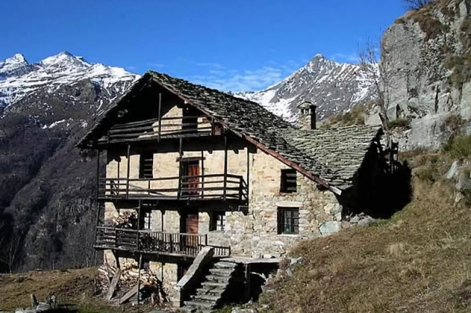
The path narrows here, and is bordered by a few stone walls. One step after another, one continues up the steep side of the valley. Just over 10,000 years ago, pastures and scrubland did not exist; the entire valley was occupied by the Lys glacier, which was retreating after the expansion of the last ice age. Almost without realising it, we arrive at the village of Lion (Leiun), which is built on the edge of a plateau suspended over the valley floor. It contains a handful of extremely interesting rural houses. The largest one has a ridge dated 1895, the main façade has four storeys and the first is accessed by a stone staircase with wide, well-connected steps, a thin stone wall acts as a handrail. A few steps away is the drinking trough carved from a single piece of irregularly shaped rock. It has been hollowed out and chiselled into a small hollow with well-worked walls.
To get to the first stadel in the Tourrison valley, one must pass the low stone houses that occupy the centre of the village, and amidst some ruins appear the old larch logs of this typical wooden construction. The very material used in its construction tells us that we are in front of an ancient house: such large larch trunks were common hundreds of years ago when man began to colonise the higher parts of the Gressoney valley, now they have almost disappeared because the woods have long since been cut down and replaced by fields and pastures.
For hundreds of years these constructions have followed the passing of the seasons lovingly guarded by the hand of man. Now the gutters made from thin logs hollowed out on the inside have fallen to the ground, a wooden door resists the carelessness of men but no longer defends the inside of the stadel where the goats enter to seek refuge. From the roof, the first drops run down between the rafters, causing them to rot. For some years now, these splendid vestiges of rural architecture have been left to their own devices, and the structures that have defied the centuries are in danger of disappearing in a few decades. As long as they are standing, climb up to see Lion's houses (1392 m, 1h15').