Mognone Hut

Edited by:
UpTheHill
Description
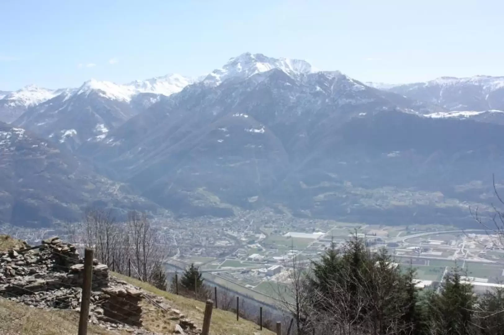
A bit of culture (if you like) The Piano di Magadino is the largest flat area in Ticino, at about 25 square kilometres. It stretches from Bellinzona to the mouth of the Ticino river for about 12 km, and has an average width of about 2 km (you who read me from Parma or around there, please don't laugh, you who when you look around see about 40,000 square km of Po Valley...). It has a slight east-west gradient (Q250 at Bellinzona, Q198 at the mouth of the Ticino). The birth of this plain (geologically) occurred in three phases: the first phase was characterised by the formation of the Alps, due to the thrust of the African tectonic plate against the European continent. The second phase took place during the various glaciations. The ice carved a U-shaped valley, starting more or less from Biasca, descending as far as Bellinzona, then turning westwards and pushing on as far as Sesto Calende, where the frontal moraine of the glacier is located, which still acts as a barrier today. The excavation was so deep that the original valley floor descended to below sea level (in the Gulf of Locarno the floor is about 100 metres below sea level). The third phase was characterised by the filling up of this immense excavation with water, filling it up to form today's Lake Maggiore (or Lake Verbano or Lake Locarno), and by the inflow of debris by the Ticino River, which gradually filled the lake (which once reached as far as Bellinzona) to form today's Piano di Magadino. At the same time, other rivers formed deltas invading the lake, the most notable being the River Maggia; on this delta we find the towns of Locarno and Ascona. Without man's intervention through his mining of inert materials at the mouths of the Ticino and Maggia, the lake would have 'broken' in two in a few tens of thousands of years: the delta of the Maggia would have reached the other side (at Magadino) forming a small body of water between Tenero and Locarno, and the rest of Lake Maggiore starting from Ascona (Interlaken, in Canton Bern, is an example of this phenomenon). Until the end of the 19th century, the Ticino River flowed freely over the Piano di Magadino, constantly changing its course, and consequently forming a marshy area where the anopheles mosquito, the carrier of malaria, thrived. Often torrential rains created frightening holes, which swept away everything in their path, such as the Torretta bridge in Bellinzona, or the famous buzza di Biasca from the 16th century. At the beginning of the 20th century, the Consorzio Correzione Fiume Ticino (which still exists today) was formed, whose purpose was to harness the river in a defined bed, make the banks safe, and reclaim the Piano di Magadino to eliminate malaria and make the surface usable by farmers. The Consortium created a stable bed, with a system of double embankments (the submersible dams, then a flat area of a few metres, followed by the insubmersible dams). Once the river had been channelled, the land could be reclaimed and for several decades it was apanaged by farmers. Communication routes were built on the edges of the Piano di Magadino, and we find the two main routes along the north side (Gordola-Cugnasco-Gudo-Sementina-Bellinzona) and on the south side (Quartino-Contone-Cadenazzo-Camorino-Giubiasco-Bellinzona). The Piano is mainly crossed by agricultural roads. The Consorzio Correzione Fiume Ticino currently maintains the dams (e.g. by restoring them after extraordinary events), the vegetation along the route, and dredging the river where necessary. The only remaining marshy area is the "Bolla di Magadino", hated by the inhabitants of the adjacent areas due to the presence of mosquitoes that make incursions in all directions, but indispensable for the overall ecosystem, since this small piece of land is widely used by passage birds to stop over during their migrations. After World War II, the Plan began to be the object of desire for industry, commerce and housing units, and its area began to be progressively eroded, starting from the sides towards the centre. Today, there are various shopping centres, industries and residential districts that have pushed into its territory, diminishing its agricultural capacity. There are various projects to safeguard the integrity of this territory, such as the creation of a park, but all these projects are continually fighting against commercial and monetary pressures, and between the two, you know who is the stronger... The Piano di Magadino is surrounded by splendid peaks, such as the Corno del Gesero, the Camoghé, Monte Bar, and the Tamaro on the south side, while on the north side we find the Gaggio summit, the cima dell'Uomo, the pizzo Vogorno, Cimetta, and a little further on (already on the lake) the pizzo Leone and the Gridone (or Ghiridone). All these peaks offer an exceptional panorama of the Piano di Magadino, Lake Maggiore, and the peaks of the Valais Alps. And now to the facts... Taking my cue from two reports, I organised with Rita the ascent to the Mognone hut, starting from San Defendente. The idea was to continue at least as far as the Orino hut, or to climb to the Orino peak, but various factors prevented us from doing so. The path immediately enters a forest that is not dense with beech trees, with a few chestnut trees despite the low altitude. The beautiful, spring-like day and the south-facing slope allowed us to climb in almost summer clothing. As we climbed, we had sweeping views of the Piano di Magadino, the various peaks surrounding it, and from the Boscalora mountains also of Lake Maggiore and the peaks towards the Valais Alps. On the way up, the chestnut disappears, to make way for various birches. All the plants had their buds ready, but were waiting for the first rains to open. In addition, the stormy wind on Thursday and Friday had broken off branches, even of a certain calibre, with all the buds lying on the ground. Encounter with a 'vipera aspis atra' along the route, at Q950. Just before the pass leading into the Sementina valley, watch out for a metal cable overhanging a few centimetres from the path: you risk a nasty fall. In the Sementina valley, the path was still covered in snow, and the ascent challenging as it was soaked and slippery. We had to climb the last 300 metres with particular caution. At Alpe Mognone, there were about 20 people (groups of 5-6), and in the hut we met a group from Como, who tour all the huts in Ticino every year. We offered chocolate and received coffee. Impressive views of the Gesero horn, the Camoghé, the San Jorio pass, Monte Bar, the Tiglio alp, the Generoso, Monte San Giorgio, Monte Tamaro on the south side, and Gridone, Pizzo Leone and the Valais Alps on the north side. We gave up the hike up to Orino (which would be almost flat) as the path was still heavily snow-covered, and due to lack of time (we started late, it's hard to get up on a Sunday morning :-) We descended the same route without any problems. We stopped on the plateau of San Defendente to photograph the little church of the same name, and enjoy the last glimpse of the Piano before descending.
Galleria fotografica


