Mezzalama Refuge, from the Frachey car park

Edited by:
Gian Mario Navillod
Updated at: 25/10/2025
Introduction
A pleasant and varied route to discover the magical world of glaciers towards one of the classic destinations for ski mountaineering. After crossing the enchanting Verra plateau and ascending the moraine of the same name, we arrive at the characteristic wooden construction built in 1934 just below the great Verra glacier, from which we enjoy a splendid panorama of the peaks of the upper Val d'Ayas surrounded by eternal snow. Adding an hour and a half of effort, after a short stretch on the glacier, you get your high mountain baptism by arriving at the Guide della Val d'Ayas refuge.
Description
Turn back about thirty paces along the asphalt road and take the lane that starts beside a canopy between the two bridges and heads northwards through a group of houses; after passing a nice rascard undergoing renovation, you arrive at the bridge over the Verra stream where you will find the sign for the regional footpaths. Following the signs for the path (7), start along the paved mule track that rises steeply beside the stream and crosses it shortly afterwards on a wooden bridge. After an initial section bordered by a few low stone walls, another section follows where the original route is lost among numerous tracks that climb haphazardly until it joins the old mule track again, which climbs lazily and with wide hairpin bends in the shade of larches until reaching the fork below the village of Fiéry.
We continue along the right-hand path, crossing a clearing where the slender shape of the Don Bosco alpine house stands out on the right, a five-storey-high stone building that is a reminder of the tourism of yesteryear. Back in the forest, follow the path that climbs with a few steep bends and occasionally splits to rejoin a little further on; where the pavement is missing and the slope becomes steeper, the tenacious roots of the larch trees hold the path while the branches offer shelter from the hot summer sun. Soon the slope decreases and the path heads to the right, almost level, in the direction of the stream that can be heard rushing at the bottom of the gorge. One crosses a circular stretch of land where the charcoal burners piled up wood and burned it slowly to make charcoal, and soon after one crosses a stream used for irrigation and joins the dirt road that leads slightly downhill to Pian di Verra. Walk along the track across the beautiful grassy plateau surrounded by the last coniferous forests, beyond which the moraine and the splendid glaciers that descend from the Breithorn, Castor and Polluce stand out imposingly, until you reach the bridge over the Verra stream.
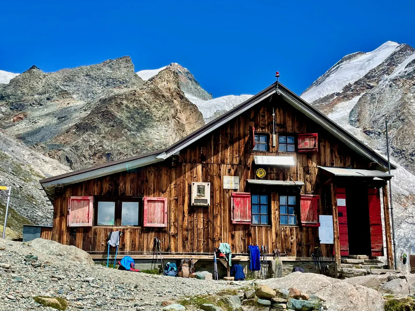
Just after the bridge, take the path (7) that begins on the left and cuts across the numerous hairpin bends of the dirt road that leads to Pian di Verra Superiore. Walking in the shade of the larch trees, one ascends the barren slope until, having emerged from the forest and near the stream that can be heard rushing on the right, one reaches the dirt road that one follows towards the interior of the valley. After a short, slightly downhill stretch that leads close to the crystal-clear water, you start climbing again, cross a small plateau and immediately after a slight bend you reach the signpost that marks the start of the path to the Mezzalama hut. Leave the dirt road for the steep path that climbs the side of the moraine in narrow bends until you reach a rock wall smoothed by the glaciers and the section from which the Val d'Ayas Guides' hut can be seen in the distance; shortly afterwards the gradient decreases, you cross a flat meadow dotted with a few boulders and arrive at the junction with the path that climbs from Pian di Verra Superiore. Keeping to the left, follow the marked path that climbs the side of the moraine with a moderate and regular gradient until you come in sight of the Mezzalama hut, recognisable by its characteristic red shutters, which is a further hour's walk away. As soon as you reach the top of the grassy slope, the wide valley carved out by the glacier appears in all its grandeur. It is barren and bare, with melt water flowing on the bottom, forming a singular contrast with the external slope now colonised by high mountain prairie on which it is not uncommon to see herds of ibex grazing. Continuing along the ridge, we can observe on the left the dark-coloured glacial tongue, which has been in constant retreat for some years now, and after a short downhill stretch, we begin to climb again until we reach the second hump where we catch our breath, about half an hour from the hut, and gaining altitude we can see the whitish waters of a glacial lake appearing on the right, in the distance. Arriving at the edge of the vegetation, where the green of the grass gives way to the grey of the stones, after a last bend the hut appears and is reached in a few minutes.