Col de Fort, from Etirol

Edited by:
Massimo Martini
Updated at: 19/10/2025
Access
From the motorway exit of Châtillon/Saint-Vincent turn left and drive up the main road to a roundabout, take the second exit and proceed west on Via E. Chanoux through the centre of Châtillon, cross the Marmore stream and take first Via Menabrea and then Via Martiri di Chesod to the right before joining the regional road , the second exit at the characteristic roundabout with the Matterhorn in the centre. Follow the regional road for 8km to Antey-Saint-André where, at Hotel Filey, turn left to take the regional road to Torgnon. Climb up the regional road for about 6 kilometres to reach the main town of Mognod. Continue straight on, following the signs for the ski lifts. After 400 metres at a hairpin bend to the left, take the municipal road on the right, following the signs for Petit Monde, Triatel and Etirol. Now continue on the narrow road until you reach the village of Triatel and finally that of Etirol, where you will find a small car park 🅿️ near the village. If the car park is full, you can turn around and park near the Moulin.
[0h31'] - [19.6km]
How to get there with GMaps
How to get there with Apple Maps
These indications are based on direct verification carried out at the time of the survey of the route, therefore the information must be verified before starting the hike. We recommend using a GPS navigator or map app on your smartphone to get up-to-date and detailed directions.
Introduction
Il Col de Fort (2.909m) è un valico poco frequentato che mette in comunicazione la Valtournenche con il vallone di Torgnon, offrendo uno sguardo insolito sul lago della Roisetta e sulla conca di Cignana. L’itinerario parte dal villaggio di Etirol, nel comune di Torgnon, e si sviluppa in un ambiente vario che alterna boschi di larici, pascoli d’alpeggio, tracce di antichi insediamenti rurali e, nelle quote superiori, pietraie e nevai residui. Il percorso, piuttosto lungo e impegnativo, permette di incontrare luoghi di notevole interesse storico come l’ospizio medievale di Chevacour e le opere idrauliche del ru de Chavacour. Il Bivacco Rivolta, situato poco sotto il colle, rappresenta un ottimo punto d’appoggio per escursioni di più giorni e per le ascensioni alla Punta Tzan e al Dôme de Tzan.
Description
0h00' From the car park, proceed straight ahead to a clearing in front of the village: take the mule track to the left that wedges between the houses of Etirol. After leaving the village, the mule track makes a few bends before turning left in a north-westerly direction. After passing alongside a rascard, the trail crosses a shady section before joining the uncultivated pastures surrounding the ruins of Levaz dessous (1,677m).
0h15' The trail veers slightly to the right and enters the Torrent de Petit Monde valley, where it meets the junction of the trail at 1,690m.
0h25' Neglect the diversions and now continue markedly uphill in the cool larch forest (Larix decidua), leaving the stream on the left until it joins the Tsantsevellà pastures.
Just before the plateau below the alpine pastures there is a stretch of thick ice: be careful in this passage. You now proceed along the track of a farm road and pass a small clearing before entering the larch forest again as you skirt the stream. After a few minutes, you reach a small bridge and a little further on, turn right and you will come to a marker indicating path to Gilliarey (1871m).
At the bridge over the Torgnon stream, an effluent of Lake Loditor, path (8) for the Tzan bivouac branches off. Care must be taken in the first few metres because water has invaded the path's seat, turning it into a small swamp, but as soon as the slope increases the problem is solved. You enter a sparse larch wood and shortly afterwards follow the main path uphill to the right; be careful not to be misled by the track that leads into the forest on the left.
Coming out of the trees, you cross a stream and after a short climb through the pastures you cross a lonely plateau. You pass an old alpine pasture and again enter the shade of the larches. At the end of the ascent, walk along a small valley, seeing a large mountain pasture in the distance on the other side of the valley, and leaving the ruins of an old lime kiln on the left, now almost covered by vegetation, continue straight on until reaching the Tour des Grandes Montagnes signpost, which you follow in the direction of Loditor. Shortly afterwards, look down and you will see the imposing ruins of the Chevacour hospice, which was used in the Middle Ages to accommodate travellers on their way to Prarayer in Valpelline and then to Switzerland via Col Collon.
You will pass above the Château alpine pasture and head along the dirt road that climbs up offering a beautiful view of the Punta Tsan. On reaching the junction with the track that follows the Verrayes channel, turn right and follow it, passing shortly afterwards the start of the path leading to the Tzan bivouac. One continues on level ground at the edge of a beautiful plateau dotted with junipers and rhododendrons. You cross two bridges crossing clear streams fed by meltwater, and at the first one you can see the catchment works of the Verrayes canal (ru de Chavacour) that carries water across the Col des Bornes to the Fontane mountain pasture in the municipality of the same name. At the next crossroads, take the track that climbs to the left and follows the bank of the stream for a stretch, then reach the lay-by where the road ends and take the path that zigzags its way through the shrubs.
A little further on, at the crossroads near a stream, continue uphill until reaching the Grande Drayère mountain pasture, where the Alta Via 1 trail intersects, leading from the Tzan bivouac to the Ersa window. Continue up the ridge following the signs for the Col de Fort, and after about ten minutes of steep bends you come out onto a plateau from which you can see the half-barrel construction of the Tzan bivouac in the distance on the right. As the path enters the scree, it gradually becomes less and less defined, while the yellow-painted stretches are joined by cairns. Pass by a boulder marked with the signpost (12) and climb up the valley at a gentle slope, leaving the boulders of an old landslide on the right.
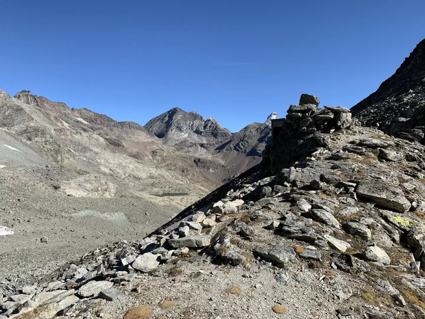
The path then heads to the northern side of the valley and becomes steeper, and as you gain height you can see, behind you, two small lakes previously hidden by boulders. You cross a small waterfall, and climb up the slope between rocks and scree until you reach a signpost that has remained unmarked. Follow the ridge in the direction of a cairn and shortly afterwards you come in sight of the bivouac, which you reach after crossing a small snowfield that lasts until late summer.
The Rivolta bivouac, equipped with 10 beds with mattresses and blankets, table, gas and pots and pans, is the preferred starting point for the ascent to Punta Tzan and the east face of Dôme de Tzan. From the Col de Fort you have a beautiful view of the Roisetta lake, the pass allows you to enter the Cignana valley from an unusual direction, you can head either towards the Barmasse hut on a marked trail or, knowing the area well, towards the Perucca hut on unmarked trails.
The descent is along the same route as the outward journey.