Challand-Saint-Anselme

Edited by:
redazione
Access
Challand-Saint-Anselme, situato a 734 metri di altitudine nella Val d'Ayas, è raggiungibile con diversi mezzi di trasporto.
Per chi viaggia in aereo, l'aeroporto più vicino è Torino Caselle, a circa 115 km di distanza. Altre opzioni includono Milano Malpensa (180 km), Milano Linate (200 km) e l'aeroporto di Ginevra (140 km).
Per quanto riguarda il trasporto ferroviario, la stazione più vicina è quella di Verrès, sulla linea Chivasso-Ivrea-Aosta, a circa 5 km dal comune. Da lì, è possibile proseguire con autobus di linea che servono la Val d'Ayas, con fermate a Challand-Saint-Victor, Challand-Saint-Anselme, Brusson e altre località fino a Saint-Jacques.
In auto, si può percorrere l'autostrada A5 Torino-Aosta fino all'uscita di Verrès, situata a circa 4 km da Challand-Saint-Anselme. Da lì, si prosegue sulla Strada Regionale 45 della Val d'Ayas, che attraversa il territorio comunale. La rete viaria provinciale è ben sviluppata e collega le principali località della valle, facilitando l'accesso al comune.
Per chi preferisce i mezzi pubblici, sono disponibili collegamenti in autobus dalla stazione ferroviaria di Verrès alla Val d'Ayas, con fermate a Challand-Saint-Anselme. Inoltre, durante la stagione invernale, sono attivi servizi di transfer dagli aeroporti di Torino Caselle e Milano Malpensa verso le principali località della Valle d'Aosta.
In sintesi, Challand-Saint-Anselme è facilmente accessibile sia con mezzi privati che pubblici, grazie a una rete di trasporti efficiente che collega la regione con le principali città e infrastrutture del nord Italia e delle aree limitrofe.
Introduction
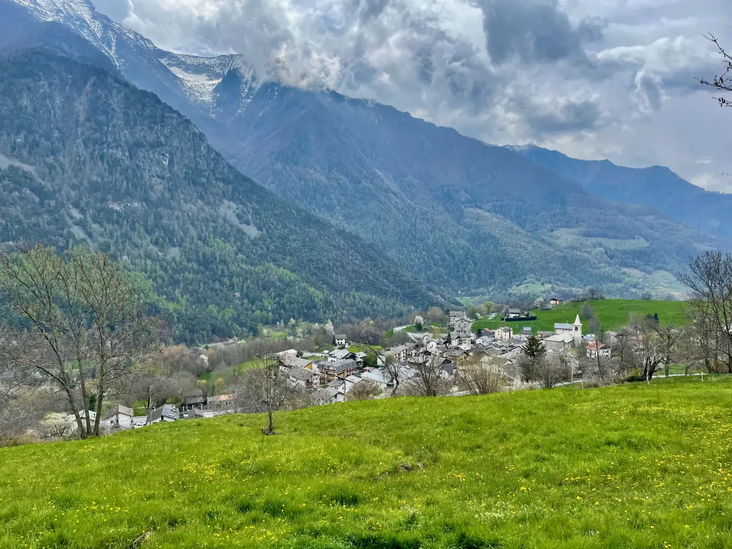
A mid-mountain commune located at the beginning of the Evançon or Ayas valley. Its main town, Quinçod is located at an altitude of 1040m, but the commune's territory extends to the 3076m of Mont Néry.Description
Information sheet
Area:
Altitude:
Maximum elevation:
Number of inhabitants:
Name in dialect:
Inhabitant name:
Patron Saint:
Internet site:
Webcam:
Neighbouring municipalities: Brusson, Challand-Saint-Victor, Emarèse, Issime
Villages and hamlets:
Landscapes:
Description
A medium-mountain municipality located at the beginning of the Evançon or Ayas valley. Its main town, Quinçod is located at an altitude of 1040m, but the commune's territory extends up to the 3076m of Mont Néry.
The town's territory extends up to the 3076m of Mont Néry.
Historically, the probable presence of the Salassi people is remembered, who were succeeded by the Romans, especially with regard to the exploitation of the various gold veins in the surrounding mountains. Mining activity continued with mixed fortunes until 1939, when the last concessionaire, Giuseppe Rivetti of Turin, decreed its definitive abandonment. Currently, the local economy is divided between the agro-pastoral sector, which exploits the extensive pastures, and the tertiary sector linked to tourism, both in summer, counting on the numerous opportunities for excursions at high altitude, and in winter, thanks to a cross-country skiing track.
The place name of the village, whose origin is not certain, is immediately associated with the memory of the noble family of the same name, which constituted the main family in Valle d'Aosta in the Middle Ages: the investiture of Bosone II as lord of the castle of Villa Challant and of the territories comprising roughly the area of the two municipalities of Challand-Saint-Anselme and Challand-Saint-Victor dates back to 1200. In 1262, Gotofredo I di Challant was Viscount of Aosta, i.e. vice-count in the name of the House of Savoy. The vicissitudes of the lineage still fascinate historians, who can follow them up to 1802, the year of the untimely death of the last male descendant.
A mid-mountain commune located at the beginning of the Evançon or Ayas valley. Its main town, Quinçod is located at an altitude of 1040m, but the commune's territory extends up to the 3076m of Mont Néry. Historically, the probable presence of the Salassi is remembered, who were succeeded by the Romans, especially with regard to the exploitation of the various gold veins in the surrounding mountains. Mining activity continued with mixed fortunes until 1939, when the last concessionaire, Giuseppe Rivetti of Turin, decreed its definitive abandonment. At present, the local economy is divided between the agro-pastoral sector, which exploits the extensive pastures, and the tertiary sector linked to tourism, both in summer, counting on the numerous possibilities of high-altitude excursions, and in winter, thanks to a cross-country skiing track. The place-name of the village, whose origin is not certain, is immediately associated with the memory of the noble family of the same name, which constituted the main family of Valle d'Aosta in the Middle Ages: the investiture of Bosone II as lord of the castle of Villa Challant and of the territories comprising roughly the area of the two municipalities of Challand-Saint-Anselme and Challand-Saint-Victor dates back to 1200. In 1262, Gotofredo I di Challant was Viscount of Aosta, i.e. vice-count in the name of the House of Savoy. The vicissitudes of the lineage still fascinate historians, who can follow them up to 1802, the year of the untimely death of the last male descendant.
Challand-Saint-Anselme: the proposed relations
.- Mountaineering
- Climbing
- Ice climbing
- hiking
- Mountain biking
- Snowshoeing
- Ski Mountaineering
- Trekking
- Walking
Community
The territory
- Geosites
- Geosites
- Lakes
- Refuges and Bivouacs
- Speaks
- Protected areas
- Cultural Heritage
- Show places on the map
Other information about the municipality
What to do in Challand-Saint-Anselme
Information
Superficie: 27,99 kmq
Altitudine: 1.030m
Maggior elevazione: 3.032m - Becca di Vlou
Numero abitanti: 740 (al 1.01.2024)
Nome in dialetto: Tchallan
Nome abitanti: Challandins
Santo Patrono: Sant'Anselmo di Aosta(7 settembre)
Comuni confinanti: Brusson, Challand-Saint-Victor, Emarèse, Issime
Sito internet: www.comune.challand-st-anselme.ao.it
Punti di interesse
- alpeggi - mappa
- villaggi - mappa
- colli - mappa
- vette - mappa
- beni culturali - mappa
- luoghi di culto - mappa
Itinerari
- escursionismo - mappa
- mountain bike - mappa
- racchette da neve - mappa
- sci-alpinismo - mappa
- trail running - mappa